
Introduction
The use of remote sensing methods to monitor 3D deformation across large areas is rapidly increasing. Radar, INSAR, Aerial LiDAR, and Drone-based LIDAR and photogrammetry can all be cost-effective and unobtrusive methods for routine monitoring of slope and ground surface deformation over large project areas.
However, one of the ongoing challenges with these remote methods is consistently maintaining high accuracy and precision of the results over extended periods of time. Best practice in remote sensing requires frequent comparisons to points (control points) on the ground to calibrate and validate the accuracy of the remote observations, particularly for critical deformation analysis trends. This term is often known as ‘traceability’ or a check of the performance of the remote sensing results. Despite these significant enhancements in the remote sensing field, the means for capturing independent precise measurements to calibrate and validate remote sensing still often remains challenging, time-consuming and expensive, often leading to a lack of validation or calibration of remotely sensed data. Surveyors are often drawn upon to perform one-off surveys for this task, using a variety of methods such as Levelling, traversing and GNSS, depending on the scale and the precision required.
Addressing this challenge, Kurloo emerges as a brilliantly simple measurement tool, providing frequent continuous measurement at high 3D precision. Kurloo’s ‘brilliantly simple’ design and high spatial and temporal accuracy make an ideal companion for calibration and validation of remotely sensed deformation monitoring results. This article explores the distinctive advantages of Kurloo and its pivotal role in the realm of remote sensing.
Comprehending Precision and Accuracy
Prior to delving into Kurloo’s contributions, it is crucial to grasp the fundamental concepts of accuracy and precision.
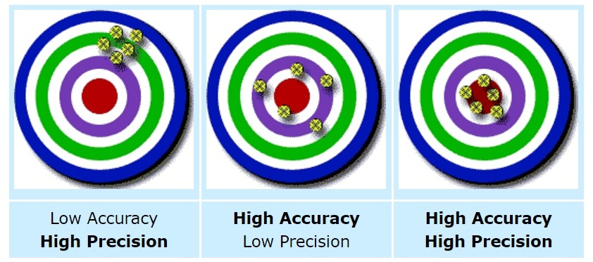
Accuracy pertains to the proximity of your measurements to the true or actual value, indicating how well your data reflects the real world. Essentially, it informs you whether you are hitting the target or how closely your measurements align with reality.
In contrast, precision emphasizes the consistency and repeatability of measurements. It evaluates how closely your measured values align with each other when you conduct the same measurement multiple times. High precision implies that the data points cluster closely together, even if they deviate from the true value.
To illustrate this, envision shooting at a target with a set of arrows. If your arrows form a tight group but are consistently off-centre from the bullseye, you exhibit high precision (consistent shots) but low accuracy (far from the actual target). Conversely, if your arrows are scattered but closer to the bullseye, you demonstrate high accuracy (closer to the target) but low precision (inconsistent shots). Ideally, one aims for both high accuracy and high precision to consistently hit the bullseye with closely grouped shots (depicted below).
In many cases, remote sensing methods like radar and InSAR excel in precision, delivering highly consistent data from one reading to the next (relative precision). However, they may fall short in terms of absolute accuracy, especially over extended periods, unless there is a system in place to validate or calibrate these results against a true or accurate value.
Validation serves to connect Earth Observation measurements taken from space to the derived data products and ground-based measurements. It enables the verification of the algorithms and models employed in deriving parameters and data products from remote sensing.
Constraints in Field Surveys for Satellite and Radar Remote Sensing
Once-off surveys, executed by proficient surveyors, are often relied upon for traceability and checks of the performance of remote sensing deformation analysis over time .. The reliability of these surveys is contingent on the expertise of the surveyor and the available equipment and methods they adopt for the survey. However, when it comes to monitoring, these surveys encounter limitations in time and cost when undertaken frequently. Monitoring environments by nature are dynamic, undergoing changes, making temporal accuracy (the time elapsed since the measurement) as crucial as spatial accuracy in evaluating comparisons to remote monitoring measurements.
Another constraint of frequent one-off surveys is the diminishing availability of skilled labour within the industry. The scarcity of proficient surveyors is increasing, often making it impractical to obtain time precise readings without long lead times. Site safety constraints also restrict some access for surveyors on some projects to simply enter a site to undertake their measurements. Through forward-thinking, Kurloo has implemented a brilliantly simple solution to address this issue, allowing surveyors to configure and automate routine measurement, and allow them to better allocate their time to more crucial and non-repetitive tasks.
The Unique Role of Kurloo
Kurloo is a game-changer in the world of deformation monitoring because it successfully combines precision and accuracy in a unique way. Here’s how Kurloo stands out:
Spatial and Temporal Accuracy: Kurloo offers exceptional spatial and temporal accuracy. This means it provides reliable consistent data that can be used to calibrate and validate decision making.
Calibration and Validation: Kurloo’s precision goes beyond what traditional surveys or remote methods can achieve alone. Its frequent precision ensures that remote sensing data can be more simply validated is accurate and reliable, addressing one of the primary challenges in the field.
Cost-Effective: Surprisingly, despite its advanced capabilities, this solution remains cost-effective, rendering it a practical choice for a diverse array of applications. It operates on the principle of Hardware and Software as a Service (HaaS), allowing users to pay only for the services they require. Another advantage is that any issues with the device or firmware upgrades, it’s all covered. Eliminating the need for a significant upfront capital investment.
Enhanced Remote Sensing Analysis: Kurloo’s high temporal accuracy significantly enhances the precision of remote sensing analysis, facilitating the generation of coincident time series data crucial for comprehending environmental changes. The Kurloo ‘Nest’ conveniently organizes the data in a user-friendly format, eliminating the need for additional software packages as everything is seamlessly included.
Conclusion
Kurloo represents a brilliantly simple solution to validate and calibrate the use of remote sensing for 3D Monitoring. Kurloo’s ability to bridge the gap between precision and accuracy is invaluable, particularly for applications requiring long-term monitoring and assessment of gradual changes. The cost-effectiveness of Kurloo, combined with its exceptional temporal accuracy, makes it a valuable tool for operations, engineers, researchers, professionals, and organisations seeking to adopt or enhance their remote sensing capabilities. As the demand for precise, accurate, and cost-efficient data collection continues to grow, Kurloo shines as a groundbreaking solution for calibration, validation, and the monitoring of gradual changes over time. It is just brilliantly simple!